


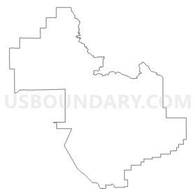
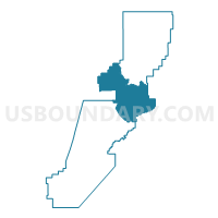
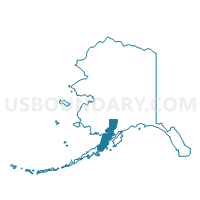
Levelock Precinct, Lake and Peninsula Borough, Alaska
About
Outline
Summary
| Unique Area Identifier | 523429 |
| Name | Levelock Precinct |
| County | Lake and Peninsula Borough |
| State | Alaska |
| Area (square miles) | 5,319.80 |
| Land Area (square miles) | 4,844.17 |
| Water Area (square miles) | 475.63 |
| % of Land Area | 91.06 |
| % of Water Area | 8.94 |
| Latitude of the Internal Point | 58.72380110 |
| Longtitude of the Internal Point | -155.71293310 |
Maps

Graphs
Select a template below for downloading or customizing gragh for Levelock Precinct, Lake and Peninsula Borough, Alaska


Neighbors
Neighoring Voting District (by Name) Neighboring Voting District on the Map
- Clarks Point Precinct, Dillingham Census Area, AK
- Egegik- Pilot Point Precinct, Lake and Peninsula Borough, AK
- Ekwok Precinct, Dillingham Census Area, AK
- Kachemak Bay Precinct, Kenai Peninsula Borough, AK
- King Salmon Precinct, Bristol Bay Borough, AK
- Kodiak Island South Precinct, Kodiak Island Borough, AK
- Kokhanok/Igiugig Precinct, Lake and Peninsula Borough, AK
- Naknek Precinct, Bristol Bay Borough, AK
- New Stuyahok Precinct, Dillingham Census Area, AK
Top 10 Neighboring County Subdivision (by Population) Neighboring County Subdivision on the Map
- Kenai-Cook Inlet census subarea, Kenai Peninsula Borough, AK (49,733)
- Kodiak Island census subarea, Kodiak Island Borough, AK (13,592)
- Dillingham census subarea, Dillingham Census Area, AK (4,847)
- Lake and Peninsula census subarea, Lake and Peninsula Borough, AK (1,631)
- Bristol Bay census subarea, Bristol Bay Borough, AK (997)
Top 10 Neighboring Place (by Population) Neighboring Place on the Map
Top 10 Neighboring Unified School District (by Population) Neighboring Unified School District on the Map
- Kenai Peninsula Borough School District, AK (55,400)
- Kodiak Island Borough School District, AK (13,592)
- Southwest Region School District, AK (2,518)
- Lake And Peninsula School District, AK (1,631)
- Bristol Bay Borough School District, AK (997)
Top 10 Neighboring State Legislative District Lower Chamber (by Population) Neighboring State Legislative District Lower Chamber on the Map
- State House District 35, Homer-Seward, AK (17,419)
- State House District 37, Bristol Bay-Aleutians, AK (15,199)
- State House District 36, Kodiak, AK (14,570)
Top 10 Neighboring State Legislative District Upper Chamber (by Population) Neighboring State Legislative District Upper Chamber on the Map
Top 10 Neighboring 111th Congressional District (by Population) Neighboring 111th Congressional District on the Map
Top 10 Neighboring Census Tract (by Population) Neighboring Census Tract on the Map
- Census Tract 1, Dillingham Census Area, AK (2,466)
- Census Tract 1, Kodiak Island Borough, AK (1,832)
- Census Tract 1, Lake and Peninsula Borough, AK (1,631)
- Census Tract 1, Bristol Bay Borough, AK (997)
- Census Tract 1, Kenai Peninsula Borough, AK (373)